The Land of Canaan
A narrow corridor between empires — and the most fought-over land in the ancient world
When God promised Abraham “unto thy seed will I give this land” (Genesis 12:7), He was promising a place unlike any other on earth. Canaan was not a remote backwater. It was a corridor — the only usable land bridge connecting Africa, Asia, and eventually Europe. Every army, every trade caravan, every cultural influence moving between Egypt and Mesopotamia had to pass through this narrow strip of land between the Mediterranean Sea and the Arabian desert.
To understand why Israel’s story unfolds here — why the conquest was necessary, why the nations were already there, why the land was simultaneously “flowing with milk and honey” and bristling with fortified cities — you have to understand the land itself.
The Levantine Corridor
Canaan occupied the southern portion of the Levant — the narrow strip of habitable land running along the eastern Mediterranean coast. Its approximate boundaries were:
- North: The Lebanon mountains and the Litani River (roughly modern southern Lebanon)
- South: The Negev desert, fading into the Sinai wilderness
- West: The Mediterranean Sea
- East: The Jordan Rift Valley and the Arabian desert beyond
The total area was remarkably small — roughly 150 miles north to south and 70 miles east to west at its widest. The entire land of Canaan was smaller than the state of New Jersey. Yet within that compact space, the terrain was astonishingly varied, the climate shifted dramatically with elevation, and the strategic importance was immense.
Why this land? God did not give Israel a hidden valley or an isolated island. He gave them the crossroads of the ancient world — a place where every empire would eventually arrive, where isolation was impossible, and where faithfulness would be tested by constant contact with other nations and their gods. The geography was the test. A people called to be “a kingdom of priests, and an holy nation” (Exodus 19:6) were placed at the intersection of civilizations — visible to everyone, influenced by everyone, accountable before everyone.
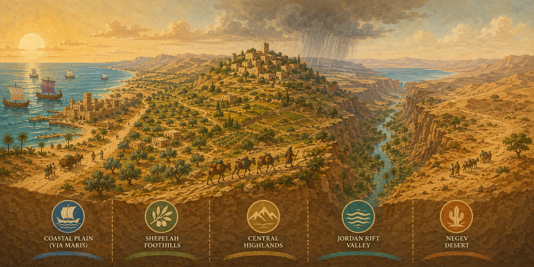
The Geographic Zones
Despite its small size, Canaan contained five distinct geographic zones running roughly north-to-south in parallel strips. Each zone had its own climate, agriculture, population density, and strategic significance — and each played a different role in Israel’s story.
1. The Coastal Plain
A flat, fertile strip along the Mediterranean — narrow in the north (around Mount Carmel) and widening southward into the broad Philistine plain. The soil was rich and well-watered, supporting grain agriculture and trade cities. This was the domain of the Philistines and the Phoenicians. Israel never fully controlled the coastal plain during the Judges period; the Philistines held the southern coast, and the Phoenician cities of Tyre and Sidon dominated the north.
The great international highway — the Via Maris (“Way of the Sea”) — ran through this zone, carrying trade and armies between Egypt and the north. Whoever controlled the coastal plain controlled the highway, and whoever controlled the highway controlled the commerce of the ancient world.
2. The Shephelah (Foothills)
The Shephelah (שְׁפֵלָה — “lowland”) was the transitional zone of rolling foothills between the coastal plain and the central highlands. Though the name means “lowland,” it was low only relative to the mountains above it. The Shephelah was characterized by broad east-west valleys separated by low ridges — natural invasion corridors from the coast into the hill country.
Strategically, the Shephelah was the buffer zone — the contested ground between the Philistine cities on the plain and the Israelite settlements in the hills. Many of the most famous biblical battles took place here: David and Goliath in the Valley of Elah, Samson’s exploits near Timnah and Lehi, and the repeated Philistine incursions that drove Israel toward monarchy. The fortified cities of Lachish, Gezer, and Beth-shemesh guarded these valley approaches.
3. The Central Highlands
The mountainous spine running north-to-south through the center of the land — from the hills of Upper Galilee (over 3,900 feet) through the Samarian highlands and down to the Judean hills around Jerusalem and Hebron. This was Israel’s heartland.
The highlands were less fertile than the coastal plain but more defensible. The terrain was rocky, the valleys narrow, and chariots — the dominant military technology of the Late Bronze Age — were nearly useless on the slopes. This is precisely why the Israelite settlement began here. The Bronze Age Collapse had weakened the lowland city-states but left the highlands largely unclaimed. Israel could settle in the hills because the hills were what the empires didn’t want — until Israel made them productive.
The central highlands contained the major Israelite cities: Shechem (where Joshua renewed the covenant — Joshua 24:1), Shiloh (where the tabernacle was established — Joshua 18:1), Bethel, Hebron (Caleb’s mountain — Joshua 14:12), and eventually Jerusalem.
4. The Jordan Rift Valley
The deepest land valley on earth — part of the Great Rift system running from Syria to East Africa. The Jordan River flows south from the Sea of Galilee (about 700 feet below sea level) to the Dead Sea (about 1,400 feet below sea level — the lowest point on the earth’s surface). The rift created a dramatic ecological divide: the western highlands receive Mediterranean rainfall, while the eastern rift floor is arid and subtropical.
Jericho sat at the base of the rift near the Dead Sea — the oldest continuously inhabited city in the region, sustained by a powerful spring in an otherwise barren landscape. The Jordan crossing (Joshua 3:14–17) was not merely a river crossing; it was a descent into and ascent out of the deepest valley on earth — a passage through a geographic underworld into the promised land.
5. The Negev
The arid southern region, transitioning from semi-arid steppe to true desert. The Hebrew negev (נֶגֶב) means “dry” or “south” and the word itself became a directional term — in Hebrew, “south” is literally “toward the dry land.” The Negev received only 4–8 inches of annual rainfall, making settled agriculture precarious without sophisticated water management.
The patriarchs spent significant time here — Abraham dwelt at Beersheba (Genesis 21:33), and the traditional expression “from Dan to Beersheba” marked the northern and southern limits of Israelite settlement. The Negev was also the buffer zone toward Egypt and the Sinai wilderness — the last stretch Israel crossed before entering the promised land.
The Trade Routes
Four major highways turned Canaan from a small territory into a strategic prize:
| Route | Path | Significance |
|---|---|---|
| Via Maris (“Way of the Sea”) | Egypt → Gaza → coastal plain → Megiddo → Hazor → Damascus → Mesopotamia | The primary international highway. Armies and trade caravans from Egypt to the north all passed through Canaan along this route. Isaiah called it “the way of the sea” (Isaiah 9:1). Megiddo controlled its key junction — giving us the word Armageddon (Har Megiddo, “Mount of Megiddo”). |
| King’s Highway | Gulf of Aqaba → Edom → Moab → Ammon → Damascus | The Transjordanian route running along the eastern plateau. Israel asked to use this road and was refused by Edom (Numbers 20:17). It connected the Arabian trade (spices, incense, gold) to Damascus and the north. |
| Ridge Route (Way of the Patriarchs) | Beersheba → Hebron → Jerusalem → Bethel → Shechem → Dothan | The highland road following the central mountain ridge. Less traveled by armies (the terrain made chariots impractical) but used by the patriarchs and later by Israelite travelers. Abraham, Isaac, and Jacob all journeyed along this route. |
| Incense Route | Southern Arabia (Sheba) → Petra → Gaza → Mediterranean | The luxury trade artery carrying frankincense, myrrh, and spices from the Arabian Peninsula northward through the Negev. The Queen of Sheba traveled this route to visit Solomon (1 Kings 10:1–13). The Nabataean city of Petra later controlled its key junction. |
The Via Maris alone made Canaan worth fighting over. Any power that controlled this highway could tax trade between two continents, project military force in both directions, and intercept rivals before they reached the heartland. Egypt understood this; so did the Hittites, Assyrians, Babylonians, Persians, Greeks, and Romans. The land of promise was also the land of perpetual contest.
“A Land Flowing with Milk and Honey”
The phrase appears over twenty times in the Old Testament, first in God’s promise to Moses at the burning bush: “I am come down to deliver them out of the hand of the Egyptians, and to bring them up out of that land unto a good land and a large, unto a land flowing with milk and honey” (Exodus 3:8).
The image was not metaphorical luxury. It was a precise description of a specific kind of abundance:
- Milk (chalav / חָלָב) — the product of herds and flocks. A land “flowing with milk” was land with enough pasture to sustain livestock year-round. This pointed to the highlands and hill country — terrain suited for grazing goats and sheep, exactly the land Israel would settle.
- Honey (devash / דְּבַשׁ) — most scholars believe this refers primarily to fruit syrup (date honey or fig honey), not bee honey. Thick, sweet syrup produced from dates and figs was a staple product of the land. A land “flowing with honey” was land where fruit trees and date palms thrived — the lower hills, oases, and irrigated valleys.
Together, “milk and honey” described a land productive at every elevation: livestock in the hills, orchards in the valleys, grain on the plains. The spies’ report confirmed it — they brought back a cluster of grapes so large that two men carried it on a pole, along with pomegranates and figs (Numbers 13:23).
Moses’ description of the land is the fullest picture:
“For the LORD thy God bringeth thee into a good land, a land of brooks of water, of fountains and depths that spring out of valleys and hills; a land of wheat, and barley, and vines, and fig trees, and pomegranates; a land of oil olive, and honey; a land wherein thou shalt eat bread without scarceness, thou shalt not lack any thing in it; a land whose stones are iron, and out of whose hills thou mayest dig brass.”
The seven species listed here — wheat, barley, grapes, figs, pomegranates, olives, and dates (honey) — became known in Jewish tradition as the shiv’at ha-minim (שִׁבְעַת הַמִּינִים), the “seven species” of the land. They represented not just agricultural products but the theological identity of the promised land itself.
Water: The Variable That Changed Everything
Canaan was not Egypt. In Egypt, the Nile provided reliable, predictable irrigation — the river flooded annually and the fields were watered whether or not anyone prayed. Canaan had no great river. The Jordan was too low in its rift valley to irrigate the highlands. Canaan depended on rain — and rain came only if it came.
This geographic reality had profound theological consequences. Moses made the connection explicit:
“For the land, whither thou goest in to possess it, is not as the land of Egypt, from whence ye came out, where thou sowedst thy seed, and wateredst it with thy foot, as a garden of herbs: But the land, whither ye go to possess it, is a land of hills and valleys, and drinketh water of the rain of heaven: A land which the LORD thy God careth for: the eyes of the LORD thy God are always upon it, from the beginning of the year even unto the end of the year.”
In Egypt, irrigation was a human technology — “wateredst it with thy foot” refers to the foot-operated water channels that directed Nile water to fields. In Canaan, water came from heaven. Israel would depend on God for rain in a way they never depended on Him for the Nile. The land was designed to make faith necessary.
This is also why Baal worship was so tempting. Baal was the storm god — the god who supposedly controlled the rain. In a land where rain meant survival and drought meant famine, the Canaanite claim that Baal controlled the weather was not an abstract theological proposition. It was a life-and-death practical appeal. (See Section 04: Ugarit & Canaanite Religion for the full picture.)
Why Canaan Was Always Contested
The land’s geography made it impossible to ignore and almost impossible to defend:
- The only land bridge. The Mediterranean on one side and the desert on the other created a narrow funnel. There was no alternative route between Egypt and Mesopotamia. Anyone who wanted to reach the other had to pass through Canaan.
- No natural fortress. Unlike Egypt (protected by deserts and the sea) or Mesopotamia (buffered by distance), Canaan had no defensible perimeter. Armies could enter from the south (Egypt’s route through the Sinai), from the north (the Beqa’a Valley between the Lebanon ranges), from the east (across the Jordan fords), or from the sea (as the Philistines and other Sea Peoples eventually did).
- Rich agricultural land. The coastal plain and the northern valleys were among the most productive farmland in the ancient Near East. The Jezreel Valley alone — the broad plain between Mount Carmel and the hills of Galilee — was an agricultural prize that attracted and sustained major powers.
- Control of trade. Whoever held Canaan taxed the trade between continents. The copper from Cyprus, the cedar from Lebanon, the grain from Egypt, the luxury goods from Mesopotamia, the incense from Arabia — all flowed through this corridor. The wealth was in the transit, not just the territory.
The result was that Canaan was never left alone. During the Middle Bronze Age, Egyptian pharaohs campaigned through it. During the Late Bronze Age, it was an Egyptian vassal state with garrisons and administrators. The Hittites contested Egypt’s control from the north. After the Bronze Age Collapse, the power vacuum allowed new peoples — Israelites, Philistines, Arameans — to establish themselves. But the vacuum was temporary. Assyria, Babylon, Persia, Greece, and Rome each arrived in turn.
The theological paradox: God promised Israel a land that could not be held by human power alone. The geography demanded dependence. A people who trusted in their own military strength would eventually be overrun — there were too many invasion routes, too many powerful neighbors, too much strategic value. Only a people whose walls were built by covenant faithfulness rather than stone could endure in this land. “Except the LORD keep the city, the watchman waketh but in vain” (Psalm 127:1).
The Landscape Israel Entered
When Joshua led Israel across the Jordan around 1400–1200 BC (depending on the chronological framework), the land they entered was not empty. It was a patchwork of fortified city-states, each controlling the farmland around it, each with its own king, its own garrison, and its own patron deity. The Canaanite peoples had been settled here for centuries. The major lowland cities — Megiddo, Hazor, Lachish, Gezer, Beth-shean — had massive walls, sophisticated water systems, and trade connections spanning the Mediterranean.
But the highlands were different. The central mountain ridge — the future heartland of Israel — was more sparsely populated, harder to farm, and less attractive to the chariot-based powers. Archaeological surveys have documented a dramatic increase in small highland settlements during the Iron Age I period (c. 1200–1000 BC), consistent with the biblical picture of Israelite settlement in the hills while the Canaanite cities persisted in the lowlands (Judges 1:19: “he could not drive out the inhabitants of the valley, because they had chariots of iron”).
The land was not a blank canvas. It was a world already built, already named, already contested. Israel entered not as settlers in wilderness but as claimants to an inheritance that others already occupied — and the God who gave the land had specific reasons for giving this land, to this people, at this moment.
Sources
Geography & Archaeology:
- Yohanan Aharoni, The Land of the Bible: A Historical Geography (Westminster Press, rev. ed. 1979) — The standard reference for the physical and historical geography of ancient Israel.
- Anson F. Rainey & R. Steven Notley, The Sacred Bridge: Carta’s Atlas of the Biblical World (Carta, 2nd ed. 2014) — Comprehensive maps and geographic analysis of the biblical world.
- Barry J. Beitzel, The New Moody Atlas of the Bible (Moody Publishers, 2009) — Detailed treatment of trade routes, topography, and regional geography.
Agriculture & “Milk and Honey”:
- Oded Borowski, Agriculture in Iron Age Israel (Eisenbrauns, 1987) — Scholarly treatment of farming practices, livestock, and agricultural products in ancient Israel.
- David C. Hopkins, The Highlands of Canaan: Agricultural Life in the Early Iron Age (Almond Press, 1985) — Archaeological analysis of highland settlement and subsistence patterns.
Scripture Citations:
- Genesis 12:7 | Exodus 3:8; 19:6 | Numbers 13:23; 20:17 | Deuteronomy 8:7–9; 11:10–12 | Joshua 3:14–17; 14:12; 18:1; 24:1 | Judges 1:19 | Isaiah 9:1 | Psalm 127:1